Live GPS + Cam
Severe weather photos and videos by
meteorologist & stormchaser J.R. Hehnly
Email questions or comments .
All images and videos on this site

Use by permission only.

Home ] Up ] Older Versions ]


Google


Don't have Google Earth?

It and the other Google Pack software is free to download and use.


See the system now running at http://www.mobilemesonet.com

We are now testing the system with multiple simultaneous observers.
Want to be a beta-tester? Click here for info.

View the PDF documentation for this project

A preview of the new system can be seen at http://www.mobilemesonet.com
NOTE: This link is to a work in progress and may not always be available or fully functional, there are known issues with the temperature and dewpoint markers on internet explorer.

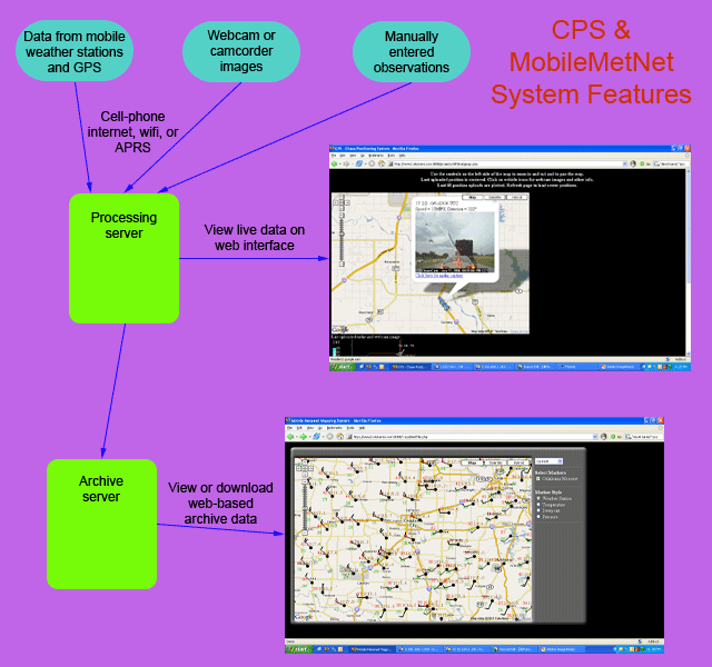
This system will be available to all chasers and spotters, letting you upload position, images, weather station data, or even manually entered observations to our server. The idea is to get simultaneous real-time views and data from around a storm event, and to archive the data for future weather research after an event.

ToDo List:

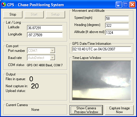
  • Put webcam capture and upload functions into CPS.exe for ease of use and so that picture and position files are made simultaneously. DONE

  • Set up mySQL database to enable archive for both webcam and position. DONE

  • Provide system for multiple chasers to be tracked simultaneously on map with tracks clickable to show webcam at that position. DONE

  • write provision for CPS to store position and webcam files until internet connection is made, then uploading all starting with latest first DONE

  • Set up server to show weather station plots on the Google map at the position the readings were taken. DONE

  • Set up observer database to display names and equipment information on the map screen.

  • Make provision to capture and upload mobile mesonet station data to send realtime temperature, dewpoint, windspeed and direction.


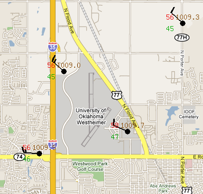
Here's the planned look for multiple observers around some weather event.


New: Added grlevel3 placefile for location and info for any users online, just add http://www.okstorms.com/~cps/grlxUsers.php to your placefile list.

Current Reader Submitted Comments:

12 comments so far (post your own)

Cool program! It works well for what it is designed to do, and it'll be interesting to see the things in the ToDo List enacted.

Posted by Jeff Snyder on Saturday, 10/15/2005 @ 22:37

Have you ever thought of using APRS?

Posted by kd5yov on Sunday, 11/13/2005 @ 20:12

kd5yov,
APRS works great for us amateur radio operators, but I wanted to make a system that anyone with internet access could use since it is becoming more and more common. Also, I'm not sure about the ability to upload images to a server via APRS.
Thanks for the question!

Posted by J.R. Hehnly on Sunday, 12/4/2005 @ 18:40

Very nice program J.R.! Thanks for sharing CPS, I look forward to trying it out this spring.

Posted by Jared Guyer on Sunday, 01/15/2006 @ 12:12

That's cool. Hey, JR, if you ever want to do something a little more real time, check out http://www.timhibbard.com/wherestim.aspx and give me a call!!

Tim

Posted by Tim Hibbard on Monday, 04/10/2006 @ 11:34

Very nice applet there. I can tell that a lot work has gone into it. Many thanks for sharing the code etc with us all.

Stuart Robinson
Leicestershire, England.

Posted by Stuart Robinson on Friday, 05/5/2006 @ 12:41

Excellent program. You've saved me a lot of work.

Posted by anonymous on Saturday, 07/8/2006 @ 03:32

HI

Your CPS.exe program works quite well.

I am having a problem however.
The speed, heading, time, and altitude are not being recorded. They do not update in the appropriate places in the CPS screen.
Is there a specific type of NMEA sentence you are looking for? I have a GPS18PC configured for NMEA 0183 $GPGGA.

Thank you for your time.

Rick

Posted by rick on Saturday, 08/26/2006 @ 18:00

This is very nice, Do you have time for some side work? I have a project that could use your knowledge and experience...

Regards, Johnathan Brouwer
The Stormcam project

please contact me asap!

Posted by Johnathan Brouwer on Thursday, 03/29/2007 @ 10:18

That is really cool guys... nice way to use a GIS system... ;)

Posted by Katie on Monday, 04/23/2007 @ 18:18

I really like the idea of including real-time images/video alongside your real-time observations, and being able to archive all this data as well. Have you taken a look at Tyler Allison\'s www.spotternetwork.org? Not to downgrade what you\'ve already accomplished, but he\'s doing a lot of similar stuff (see for example: http://tinyurl.com/4xwy4n)...perhaps a mutual venture could take place. Just a thought.

Posted by Jason on Tuesday, 04/8/2008 @ 16:29

i want the gps in my mobile but how that i dont know

Posted by aditya mayur on Sunday, 09/7/2008 @ 07:01

Leave your comments on this page:

Name:

Email:

URL:

http://


To prove you are a human, please type a $ three times in this box


Comments:


Note: Emails will not be visible or used in any way, and are not required. Please keep comments relevant. Any content deemed inappropriate or offensive may be edited and/or deleted.

No HTML code is allowed. URLs will be auto-linked.


[ Live GPS + Cam ] MAME Arcade ] Epods ]


Home ] Video Sales ] Weather & Chasing ] Personal Scrapbook ] Projects ] Search ]


Send your questions or comments to