2006 Chases
Severe weather photos and videos by
meteorologist & stormchaser J.R. Hehnly
Email questions or comments .
All images and videos on this site

Use by permission only.

Home Up March 20, 2006 March 30, 2006 April 1, 2006 April 6, 2006 April 20, 2006 April 24, 2006 April 28, 2006


17:19:46 - Rainbow behind an oil pump.
March 20, 2006 - Central Oklahoma

US 166 near Cedar Vale, KS - New storms northeast of Wichita
March 30, 2006 - Oklahoma and Kansas

10 miles south of Sayre, OK - Storm becomes outflow dominant and cool air rushes out, cutting off inflow.
April 1, 2006 Shamrock, TX to western Oklahoma

12 miles west of Parsons, KS
April 6, 2006 - Northeast Oklahoma and Southeast Kansas

East of Lamesa, TX - Clouds, illuminated by the city of Lamesa, show the incredible shear in the area. Any rising motion is accompanied by some intense twisting motions.
April 20, 2006 - West Texas, Lamesa

West Oklahoma City - I can finally see the second tornado in El Reno, it is 23 miles away.
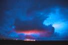
April 24, 2006 - North and Central Oklahoma, El Reno Tornado

16:46:38 - We finally get some convection west of Childress, but the cold front coming from the north cuts off the inflow.
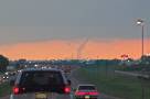
April 28, 2006 - Near Childress, Texas


Favorite Photos 1998 and Before 1999 Chases 2000 Chases 2001 Chases 2002 Chases 2003 Chases 2004 Chases 2005 Chases 2006 Chases 2007 Chases 2008 Chases 2009 Chases 2010 Chases People & Places Other Weather Storm Chasing Vehicle Skywarn Merchandise


Home Blog Video Sales Weather & Chasing Personal Scrapbook Projects Search


Send your questions or comments to